
Tuesday, May 31, 2011
Lake District-England
Great Barrier Reef, Australia

The Great Barrier Reef can be seen from outer space and is the world's biggest single structure made by living organisms. This reef structure is composed of and built by billions of tiny organisms, known as coral polyps. This reef supports a wide diversity of life, and was selected as a World Heritage Site in 1981. CNN labeled it one of the seven natural wonders of the world. The Queensland National Trust named it a state icon of Queensland.

A large part of the reef is protected by the Great Barrier Reef Marine Park, which helps to limit the impact of human use, such as fishing and tourism. Other environmental pressures on the reef and its ecosystem include runoff, climate change accompanied by mass coral bleaching, and cyclic population outbreaks of the crown-of-thorns starfish.
The Great Barrier Reef has long been known to and used by the Aboriginal Australian and Torres Strait Islander peoples, and is an important part of local groups' cultures and spirituality. The reef is a very popular destination for tourists, especially in the Whitsunday Islands and Cairns regions. Tourism is an important economic activity for the region, generating $1 billion per year.
Sahara Desert, Africa

Some of the sand dunes can reach 180 metres in height

Himalayas, Asia
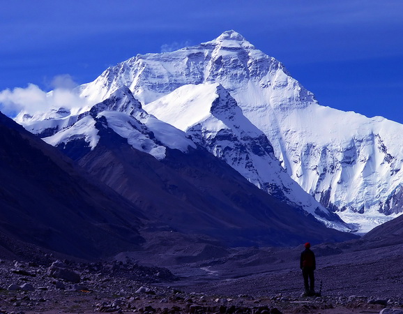
Together, the Himalayan mountain system is the planet's highest, and home to the world's highest peaks, the Eight-thousanders, which include Mount Everest and K2. To comprehend the enormous scale of this mountain range, consider that Aconcagua, in the Andes, at 6,962 metres is the highest peak outside Asia, whereas the Himalayan system includes over 100 mountains exceeding 7,200 m.
The main Himalaya range runs west to east, from the Indus river valley to the Brahmaputra river valley, forming an arc 2,400 km (1,491 mi) long, which varies in width from 400 km (249 mi) in the western Kashmir-Xinjiang region to 150 km (93 mi) in the eastern Tibet-Arunachal Pradesh region. The range consists of three coextensive sub-ranges, with the northernmost, and highest, known as the Great or Inner Himalayas.

Some of the world's major river systems arise in the Himalayas, and their combined drainage basin is home to some 3 billion people (almost half of Earth's population) in 18 countries. The Himalayas have profoundly shaped the cultures of South Asia; many Himalayan peaks are sacred in Hinduism, Buddhism and Sikhism.
Geologically, the origin of the Himalayas is the impact of the Indian tectonic plate traveling northward at 15 cm per year to impact the Eurasian continent, about 40-50 million years ago. The formation of the Himalayan arc resulted since the lighter rock of the seabeds of that time were easily uplifted into mountains. An often-cited fact used to illustrate this process is that the summit of Mount Everest is made of marine limestone.
Amazon Rainforest, South America


The Amazon rainforest was short-listed in 2008 as a candidate to one of the New7Wonders of Nature by the New Seven Wonders of the World Foundation. As of February 2009 the Amazon was ranking first in Group E, the category for forests, national parks and nature reserves.
Monday, May 30, 2011
Bora Bora, French Polynesia


Bora Bora is a major international tourist destination, famous for its aqua-centric luxury resorts. The island is served by Bora Bora Airport on Motu Mete in the north, with Air Tahiti providing daily flights to and from Papeete on Tahiti. The major settlement, Vaitape is on the western side of the main island, opposite the main channel into the lagoon. Produce of the island is mostly limited to what can be obtained from the sea and the plentiful coconut trees, which were historically of economic importance for copra. According to a census performed in 2008, the permanent population of Bora Bora is 8,880.
Teotihuacan, Mexico

The city was thought to have been established around 100 BCE and continued to be built until about 250 CE. The city may have lasted until sometime between the 7th and 8th centuries CE. At its zenith, perhaps in the first half of the 1st millennium CE, Teotihuacan was the largest city in the pre-Columbian Americas. At this time it may have had more than 200,000 inhabitants, placing it among the largest cities of the world in this period. Teotihuacan was even home to multi-floor apartment compounds built to accommodate this large population. The civilization and cultural complex associated with the site is also referred to as Teotihuacan or Teotihuacano.

Although it is a subject of debate whether Teotihuacan was the center of a state empire, its influence throughout Mesoamerica is well documented; evidence of Teotihuacano presence can be seen at numerous sites in Veracruz and the Maya region. The Aztecs may have been influenced by this city. The ethnicity of the inhabitants of Teotihuacan is also a subject of debate. Possible candidates are the Nahua, Otomi or Totonac ethnic groups. Scholars have also suggested that Teotihuacan was a multiethnic state.
The city and the archaeological site were located in what is now the San Juan Teotihuacán municipality in the State of México, Mexico, approximately 40 kilometres northeast of Mexico City. The site covers a total surface area of 83 km² and was designated a UNESCO World Heritage Site in 1987. It is one of the most visited archaeological sites in Mexico.
Subscribe to:
Posts (Atom)